A Trip to the East Coast
A Long Drive for a Small Boat
May, 2011
Click on any image for a larger view;
Contact garya at this domain if you would like the high quality image for printing
After picking up our new dory, we crossed over Lake Champlain in a howling wind.
I did not feel particularly comfortable driving a small, light car with a largish boat on top
that wanted to act like a kite.
We boogied as rapidly as we could to the west,
crossing back into Canada.
We stopped for lunch at a provincial park called
The Chutes.
It got its name because they used to have some big wooden chutes to float logs
over the waterfall and on down the Aux Sables River.
The chutes prevented the logs from getting all jammed up in the falls
where it would be too dangerous to free them up.
There are no chutes left,
but here's a pointer to one that was rebuilt in a different place, the
Hawk Lake Log Chute.
 |
| The Chutes |
 |
 |
| Chutes |
Chutes |
 |
| Below the Chutes |
 |
 |
| Dona and Max on one of the Bridges at The Chutes |
Dona and Max |
 |
 |
| More Chutes |
It is a Gnarly stretch of river! |
 |
 |
| Chutes |
Chutes |
 |
| Chutes |
We continued on to Lake Superior, where we spent the night at a skinny state park
sandwiched between the road and the lake.
We put our new "Hunky Dory" into the lake to christen her,
and enjoyed a wonderful sunset to the calls of loons.
It doesn't get much better than that --
there weren't even any mosquitoes!
(at the particular instant...)
 |
| Dona and our "Hunky Dory" on Lake Superior |
 |
 |
| Dory Dona Lake Superior |
Dory Dona Lake Superior |
 |
| Loons on Lake Superior |
 |
 |
| Morning Fog on Lake Superior |
Camp Spot on Lake Superior |
Lake Superior was gorgeous,
and it really made me want to spend a summer and fall sailing around up there
exploring all the little islands and coves.
I guess I need another lifetime...
 |
| Lake Superior |
 |
| Lake Superior |
We continued on through
Lake Superior Provincial Park,
wishing we had more time to stop and explore.
We stopped at
Agawa Rock and hiked down
to see the pictographs painted on the rocks at the lake shore.
It was pretty easy to imagine early Americans making their way along the shore,
camping here and painting on the rocks.
There was a great chockstone precariously wedged far out in the slot we were hiking down;
I wouldn't want to be underneath it in an earthquake...
 |
 |
| Agawa Rock Chockstone |
Agawa Rock Chockstone |
 |
Lake Superior at Agawa Rock
Pictographs are on the Rock Wall at Left |
 |
 |
| Agawa Rock Pictographs -- Fish? |
Agawa Rock Pictographs --
A Canoe, a Snake, and some other Beast |
 |
 |
Agawa Rock Pictographs --
A Horse and Other Stuff |
Agawa Rock Pictographs -- Canoes? |
We enjoyed seeing a few birds on the hike out.
 |
 |
 |
| Xxx Bird |
Downey Woodpecker |
Downey Woodpecker |
We continued on around the north shore of the lake,
stopping to check out some great beaches and rivers along the way.
 |
 |
| Lake Superior |
Lake Superior |
 |
 |
| Lake Superior |
River flowing into Lake Superior |
When we got to highway 11 we turned north,
heading for the town of Jellicoe.
My paternal grandfather had a fishing resort up on Partridge Lake
and I wanted to see it again.
I hadn't been back there since I was a little squirt.
Mom had given me instructions,
but unfortunately all the good maps were still down at her house.
The instructions were wrong,
and we got there late in the evening,
and none of the few people we talked to had any idea where Partridge Lake was.
One of them would point one way,
and the next one would point the other way.
Our instructions were "about seven miles west of Jellicoe,"
but it was really about seven miles east.
Dang.
We found a place, and took some pictures, but it was the wrong place.
Maybe I'll get back there again before I die; who knows?
 |
 |
| Not Grandpa's Place on Not Partridge Lake |
Not Grandpa's Place on Not Partridge Lake |
The country up there is flat.
Really flat.
Exceedingly flat.
It's easy to see how the early european explorers used canoes to travel all around that country.
It's not easy to understand how they navigated,
as there are few landmarks you can see from very far away.
But at least all water flows downhill,
and maybe it didn't matter too much if you were just exploring...
It also looked like a place where the mosquitoes could drive you absolutely crazy.
We didn't have too many of them, but it was still pretty early in the season.
 |
 |
| Not Grandpa's Place on Not Partridge Lake |
Not Grandpa's Place on Not Partridge Lake
but hey, it was pretty at sunset! |
Then it was back down to Lake Superior,
where we went hiking up Sleeping Giant
and spent the night at another great park.
 |
| Sleeping Giant |
 |
 |
| The Sea Lion Rock near Sleeping Giant |
Sleeping Giant Creek |
As a sailor, it was comforting to me whenever I would see a lighthouse on one of the islands in Lake Superior.
Lake Superior is notorious for its storms,
and the rocky shoreline is pretty unforgiving.
Any help to navigation would be pretty welcome, just about any time.
 |
| Lighthouse on an Island off Sleeping Giant |
Our hike took us past a great little bay called "Tee Harbour;"
once again, I wished we were on a sailboat.
 |
| Campsite at Tee Harbour |
 |
 |
 |
 |
| Snowshoe Hare |
Woodpecker Tree |
Woodpecker Tree |
Pond on the way up |
As we got higher, we could look down on Tee Harbour.
There was a sailboat coming in past the island with the lighthouse;
what a way to spend a gorgeous spring day!
 |
| Sailboat passing island with lighthouse |
But we had our own great way to spend the day,
hiking up a mountain for a great view.
 |
 |
| Dona on the way up Sleeping Giant |
Dona on top of Sleeping Giant |
 |
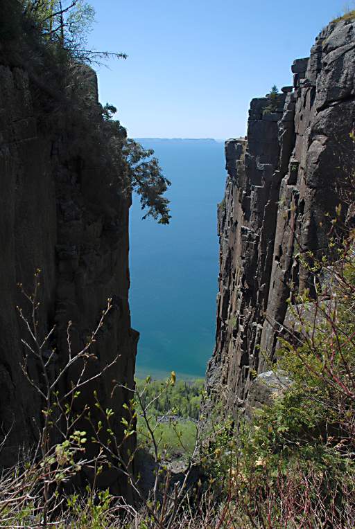
| The Cliffs of Sleeping Giant |
With all that hard rock up there,
they have boatloads of cracks.
It seems like just about everywhere we went
there was a big crack to look at.
They were all cool, and I never got tired of them.
| Last Views of Lake Superior |
After Lake Superior, we were out of scenic wonders.
It was a long way across North Dakota and eastern Montana
until we finally saw some more mountains and felt at home again.
But along the way
we passed through some kind of a time warp.
It was scary,
and we were glad we were zipping by in a fast vehicle.